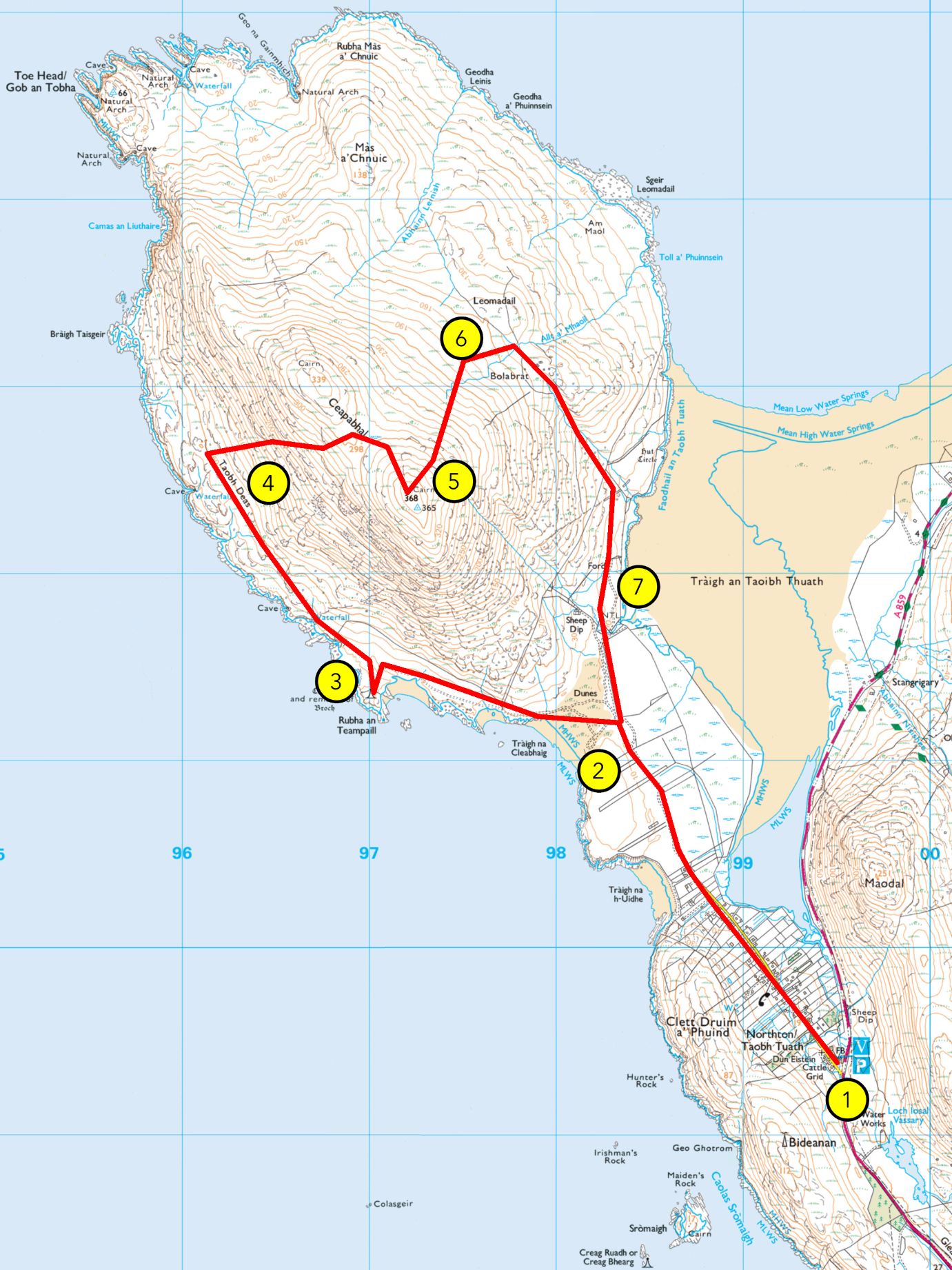
From Hebrides People Visitor Centre an Teampall (and Bràigh Taisgeir)
Grade: B (A if stopping at an Teampall)
Length: 7 miles (4.5 miles) /11km (7km), about 3 hours (2 hours)
Terrain: vehicular road, gravel path, machair/grassland, sand, peatland bog and moorland
Plants: red and white clover, daisies, buttercups, bird’s-foot-trefoil, orchids, sea pink, ragged robin, harebell, marram grass, sand sedge, etc.
Wildlife: machair birds like lapwings, corncrakes, meadow pipits, skylarks, pied wagtails, etc., coastal birds like sea eagles, oystercatchers, plovers, curlews, herring gulls and kittiwakes.
Guided Walk
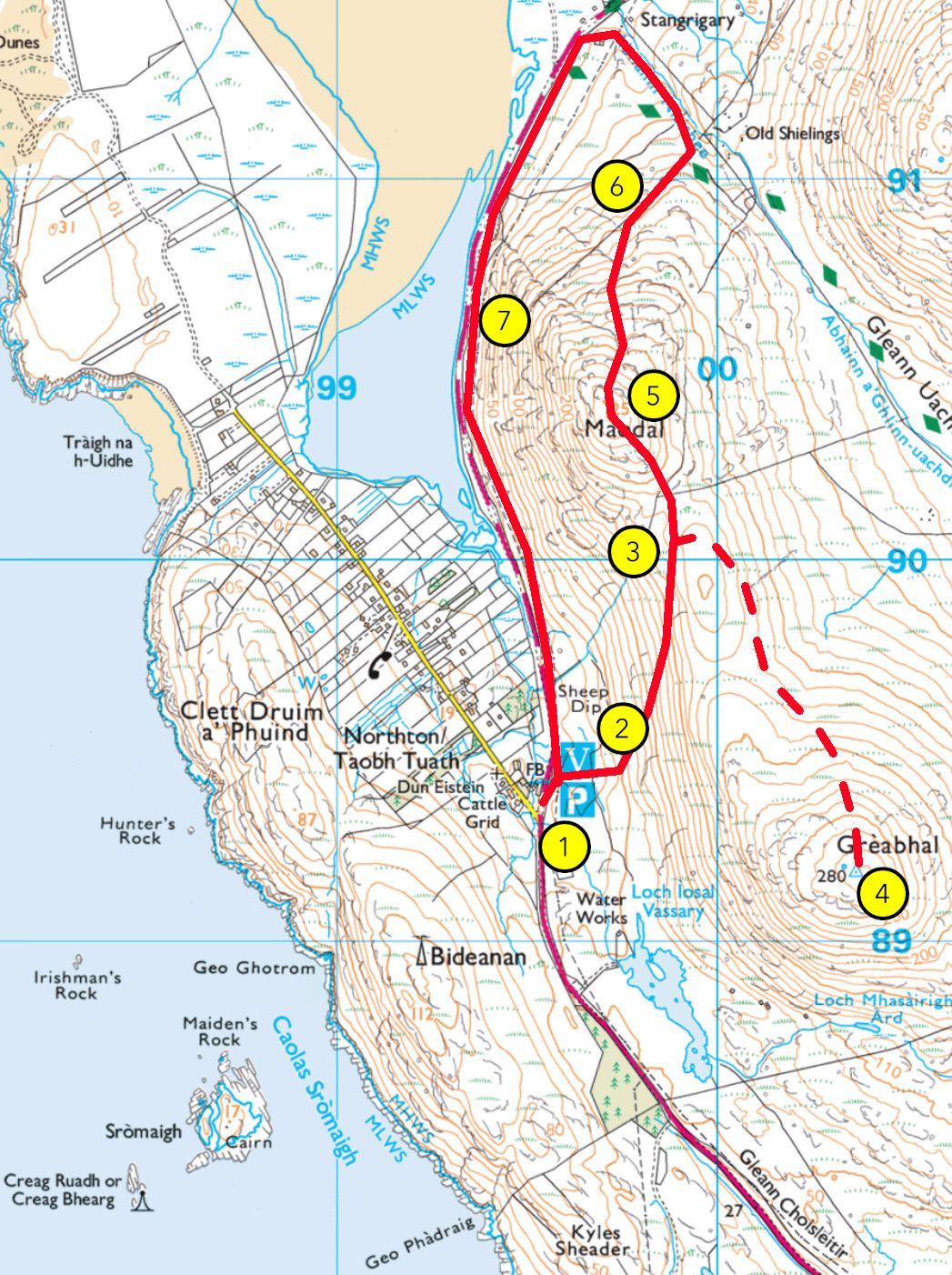
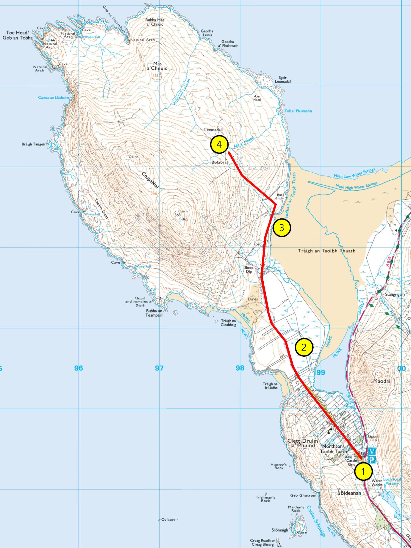
1. An Taobh Tuath / Northton
This township is known as An Taobh Tuath in Gaelic, and Northton in English. This township was formed in 1902 and is therefore still relatively ‘new’. Today’s township consists of 41 crofts and in its heyday, had 3 shops, a post office, a bus garage, a motorcycle mot centre, a school and a mission house. Today Northton has just over 60 full time residents.
The original An Taobh Tuath (literally translated as the North Side) was located on the north side of Ceapabhal, the hill ahead of you. There was another settlement on the hill called An Taobh Deas (literally the South Side) on the south side of Ceapabhal. As well as these two settlements, there was also the Uidh (an isthmus) and Druim a’ Phuinnd, above where the township is sited now.
The name An Taobh Tuath moved over the years from the north side of Ceapabhal to where the fank stands today on the hill where there used to be a large farm, and where the renowned William MacGillivray spent a lot of time. When the existing township came into being, the name simply moved from the area where the fank is to where the township is today. Despite being ‘the north side’, Northton is very much in the south!
Once you reach the end of the township, you’ll pass through a gate onto a rougher path that cuts through further croft land.
2. Northton Machair
You are now crossing croft land. The first part you’re walking through are extensions of the crofts in the township. Once you pass through you the second gate, you’ll then be on the common grazings but more on that later.
Crofting is an important part of the social and cultural life of the Highlands and Islands, and while its economic value has decreased with changes in the lifestyle, it is still an important part of islanders’ lives. Depending on the time of year, you may see lambs running around or maybe some crofters ploughing, planting or tending to their crops – usually potatoes, but also sometimes corn. The land here is part of Northton Bay Site of Special Scientific Interest or SSSI. Some of the reasons this area is so designated is because of the flora and fauna that can be seen. Again, depending on the time of year, look out for red and white clover, daisies, buttercups, etc., as well as lapwings, corncrake, curlews, etc. There may also be sheep and cattle around.
Continue on the path through the second gate onto the common grazings, sticking to the left when there’s a fork in the track.
The coast around this region of Harris is very sandy, but this is not the case everywhere in Harris. The east coast of the Harris mainland, as well as most of North Harris, are home to rocky shores and shingle beaches. You should be passing a beach to your left called Tràigh na Cleabhaig, and further ahead will be a couple of other beaches, including Tràigh an Teampaill. Tràigh is Gaelic for a sandy beach.
Shingle beaches bear various other names depending on their nature. The word mol is by far the most common, designating low rocky shores covered in pebbles, rocks, and slabs of various sizes. The word faolainn is also occasionally found, mostly designating a beach made up of small round pebbles. Finally, the word morghan applies to a beach in which the pebbles are extremely fine, but not quite sand. These various types of shores offer different habitats for coastal species, and are all prone to changes depending on climactic conditions such as storms and rising sea-levels.
Apart from the beach at the end of Northton township, which is called the Mol for the reasons already given, the other beaches you will see here, are all tràighean or sandy beaches.
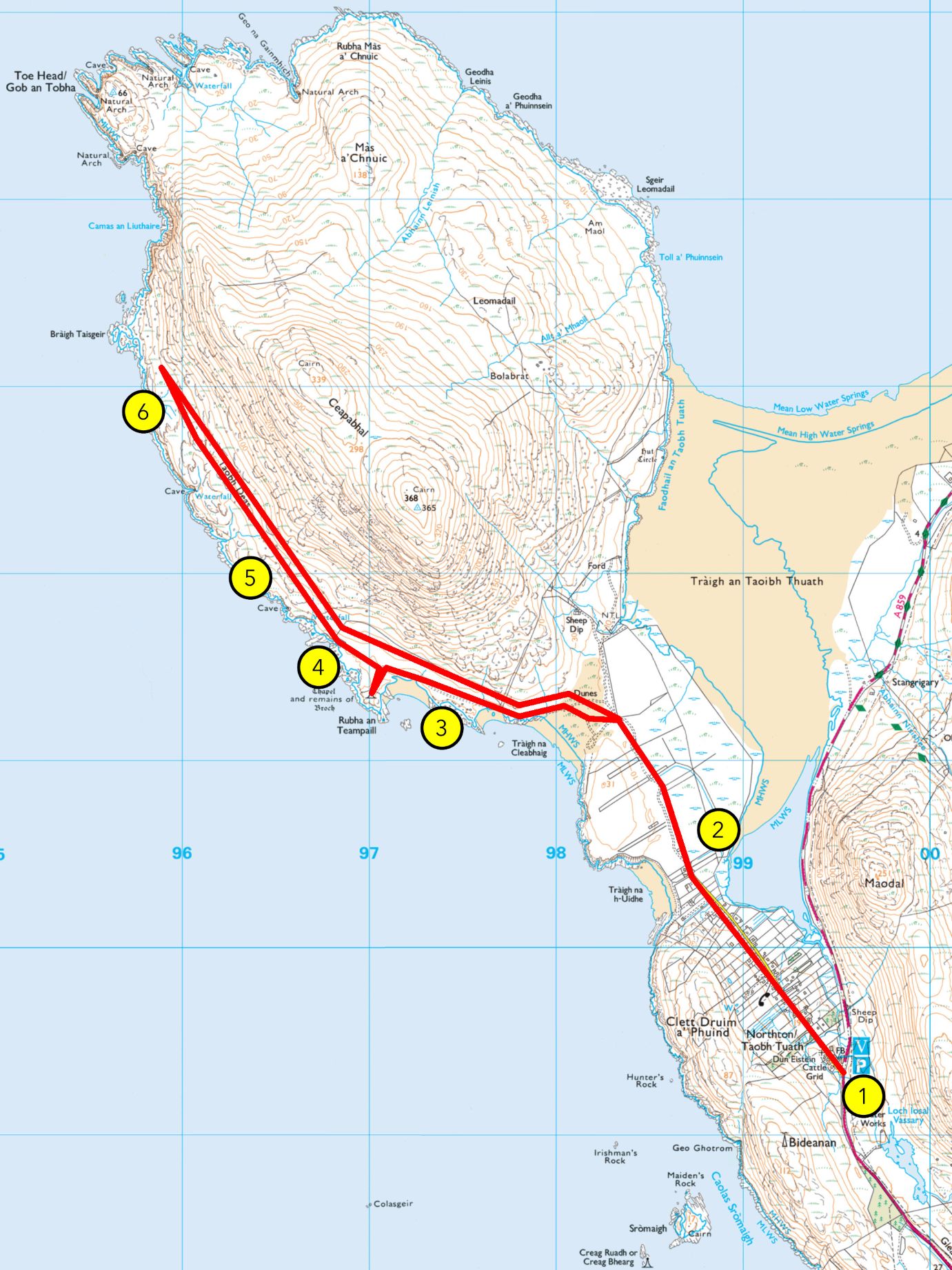
3. An Teampall
Keep on the track to An Teampall, the small, ruined chapel that should soon appear ahead of you.
As you go through the gate, you’re now in Pairc an Teampall – Temple Park in English – and heading towards Rubha an Teampall and the Teampall itself. Rubha an Teampall is the headland of the chapel and from your vantage point as you walk up the small incline, you should be able to see the headland upon which the ruined chapel sits.
You can either follow the track around and approach the Teampall head on or cut down along the beach, tràigh an Teampall and up towards the gable end of the Teampall.
The small chapel you see in front of you is known as Teampall na h-Uidhe, the Temple of the Isthmus. This site is much older, however. If you look around you, you’ll notice that the building stands in an enclosure made up of a low stone wall, now mostly overgrown. This used to be a broch, a type of fort that is commonly found in the area. This broch was part of a series of defensive structures located all around Harris, with a particular concentration in the west of Harris. Other such buildings are found in Borve, Taransay, and at Àird Grothadanais north of Luskentyre, to only name a few. Brochs are also known as dùn in Gaelic (think of Dundee, Dunoon, or Dumbarton).
The area around Ceapabhal is among the oldest known settlements of the Western Isles, with some sites dating to 3000 BC at least. The church building you can see today was built in 1528 upon an older religious site. A Christian settlement was created here by missionaries in the area before the first Viking raids of the 9th century, and the remnants of a cell used by monks for meditative isolation, were found on Eilean Hopraidh, north of Ceapabhal. The nearby island of Pabaigh, meaning “Island of the Christian Priests” in Old Norse, is another witness of that history.
If you wish to stop your walk here, you can make your way back whence you came. Otherwise, continue north and cross the drystone wall where the fence is broken, near the shore. **is this the best way to advise them to carry on?
4. Moorland and Feannagan
Moorland and peatlands, known in Gaelic as mòinteach, make up most of the Harris landscape. The acidic soil means that not every species can thrive here, and heather dominates the landscape, often limiting other plants. However, this landscape is richer than it appears and in the summer months you will see many plants and flowers growing in the area, including tormentil, milkwort, lousewort, marsh orchids, and much more. Boggier bits will also reveal our local carnivorous plants, the butterwort and the sundew. Moorland birds also find their fair share of insects to eat, and you should see the clacharan, or stonechat, and gocaman cuthaige, or meadow pipits, among others.
Ahead of you, the moorland landscape bears the clear traces of human activities. Those are called feannagan, or lazybeds, and consist of a series of ridge and furrow. These were common throughout Europe but are now mostly used by the people of Western Scotland and Ireland. This method allows to build more ground depth where it is irregular. In Harris, seaweed was added to the dirt to provide fertiliser. While now mostly used for potato crops, it was also used for barley, oats, and many other vegetables until a few decades ago.
Keep on ahead until you reach some ruins atop a greener knoll.
5. An Taobh Deas
You are now at the heart of An Taobh Deas. This was not a significant settlement by any means, but we have proof enough that people inhabited this place. The smaller, round buildings are shielings, which were mostly summer dwellings for people bringing their animals to graze away from the winter pasture, in order to allow them to regenerate. Other buildings buried in the heather, as well as the feannagan we have already seen, are testament of more permanent land use. This place is known as An Taobh Deas, “the south side” in Gaelic, in relation to An Taobh Tuath, “the north side”, which used to be located north of Ceapabhal before moving to where Northton now stands.
Keep ahead on the low ground to the last headland before the cliffs to go to the end of this walk.
6. Bràigh Taisgeir
This is the endpoint of this walk, whence you will make your way back. Ahead of you, you will see the many islands of the southern part of the Harris archipelago, including Copaigh, Siolaigh, Pabaigh, and farther south, Beàrnaraigh, the southernmost island of Harris. Farther lie Uist and Benbecula. Far off to the west, on a clear day, you may see an enormous island, high on the horizon: This is Saint Kilda, known in Gaelic as Hiort.
The name of Harris probably comes from the Old Norse Hærri, meaning “the Higher Places”, a plural still found in the Gaelic name Na Hearadh, and reflected in the contemporary English Harris. This plural quality refers to the fact that Harris is an archipelago made up of many islands, even though it is now common in English to refer to it as an island. Apart from the Harris mainland, only three islands are now permanently settled: Beàrnaraigh, Scalpaigh, and Sgeotasaigh. The others, such as Saint Kilda, Tarasaigh, Pabaigh, or Scarp, were cleared, evacuated, or slowly abandoned during the 19th and 20th centuries.
To your right, the cliffs are cutting you off from Gob an Tobha and the northern coast of Ceapabhal. There, several coastal caves and high cliffs make for a dangerous and remote shoreline. One of these caves is known as Leabaidh an Aisteir, “the devil’s bed”, due to a flat horizontal slab inside of it. It was the hiding place for Dòmhnall Beàrnaraigh, or Dòmhnall MacLeòid, known as An Tròidean, the Old Trojan. He was the uncle of the chieftain of the MacLeods of Harris and in 1745, despite his nephews orders not to join the Jacobite Rising, An Troidean gathered twenty men from Harris and left to the aid of the Prince. He survived the Battle of Culloden and came back as a fugitive to Harris, hiding first in Uamh Uladail in North Harris, before moving here. He was later pardonned and ended his life in 1781 at the age of 88 years old in his home, having had 29 children.