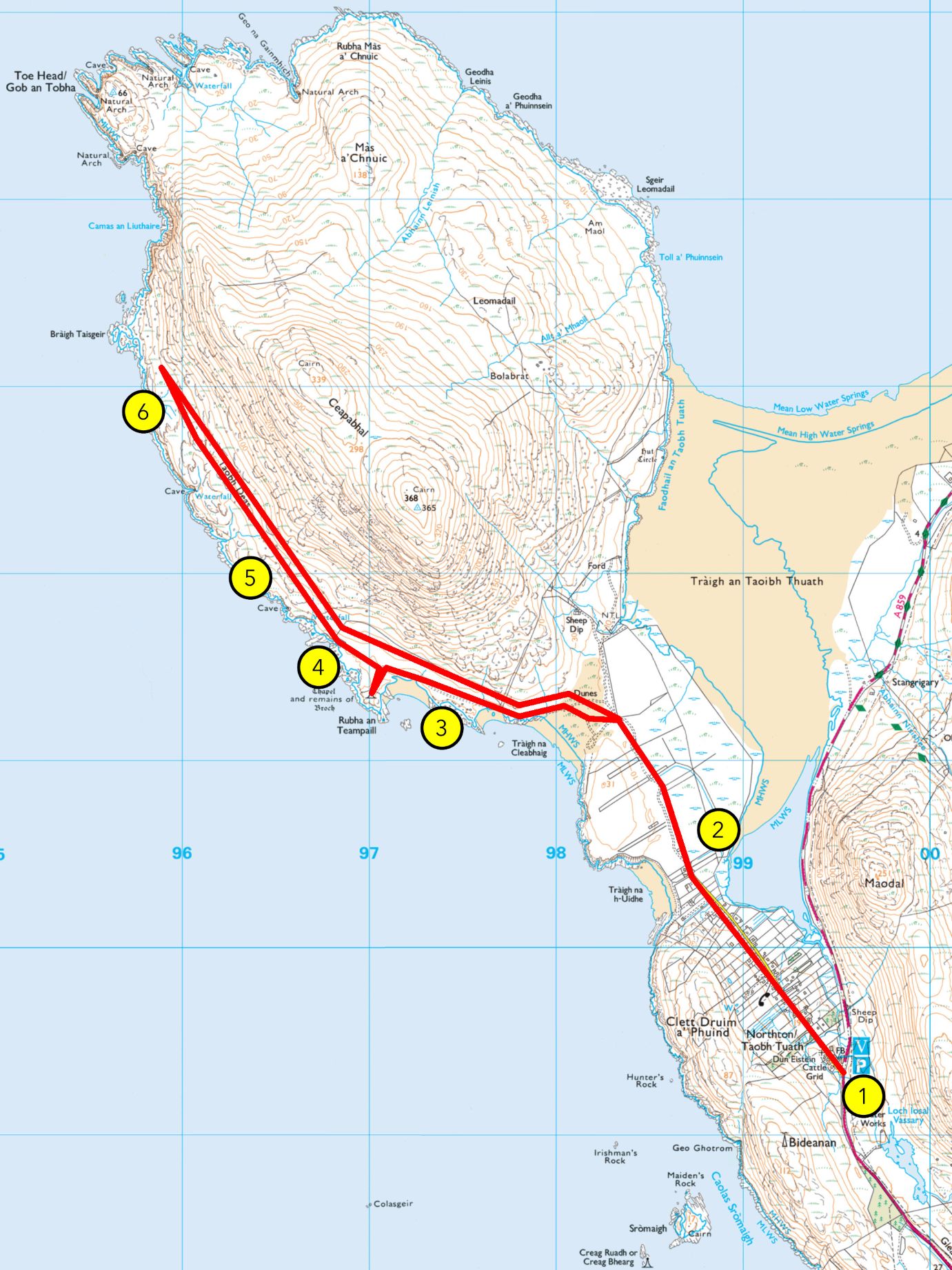
From Hebrides People Visitor Centre to Ceapabhal summit
Grade: C
Length: 7.5 miles/12km, about 4 hours
Terrain: vehicular road, gravel path, machair, grassland, sand, peatland bog, moorland and steep rocky hillside
Wildlife: moorland birds including meadow pipit, stonechat, red grouse, wheatear, wrens and golden eagles, coastal birds like sea eagles, lapwing, greylag geese, kittiwake, herring gulls, oystercatchers, plovers and loons
This extended walk begins with the same route as Walk 1, before hiking up Ceapabhal, and is recommended for experienced walkers.
Guided Walk
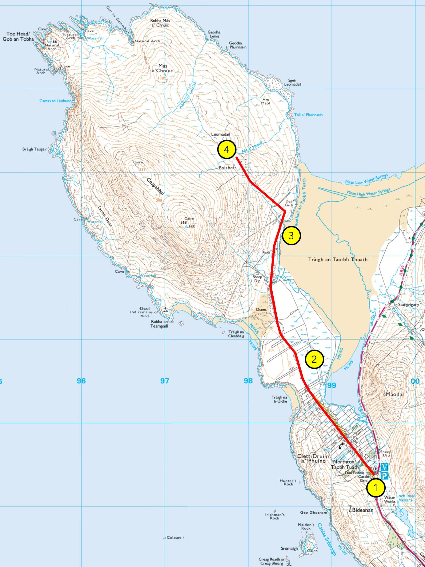
1. An Taobh Tuath / Northton
This township is known as An Taobh Tuath in Gaelic, and Northton in English. This is not where An Taobh Tuath used to be, and this area is still known as Druim a’ Phuinnd, the original name of this township. All the way to the end of the 19th century, An Taobh Tuath was actually located north of Ceapbhal, the mountain ahead of you, hence the name. It has moved from there southwards, to Druim a’ Phuinnd, taking its name with it. Another small settlement called An Taobh Deas, or the South Side, was located south of Ceapabhal. It is now strangely located north of An Taobh Tuath.
Keep following the road until you pass the gate to a rougher path on the common grazing.
2. Northton Machair
You are now crossing croft land. Most of what you see ahead of you is called cùl-cinn, or common grazing, and is shared by local crofters. Crofting is an important part of the social and cultural life of the Highlands and Islands, and while its economic value has decreased with changes in the lifestyle, it is still a form of survival agriculture to many indigenous families. This common grazing, located on the Northton Site of Special Scientific Interest, or SSSI, is particularly valuable as the sandy machair soil provides the animals with good grass rather than the poorer moorland soil found around the hills. Machair also makes for good planting ground, and while crops are now rarely seen in these parts, crofters elsewhere in the Hebrides do cultivate areas of machair. The word machair is Gaelic and was borrowed into English as most of the machair land in the world is located on the west coasts of Scotland and Ireland, which are historically Gaelic speaking.
You may see many birds among the sheep and cattle, not least of which the currucag, or lapwing. You will recognise it thanks to its crest and rounded wings, which make for a distinct flight pattern.
Continue onto the path to the north-west, sticking to the left as you reach the foot of the mountain.
The coast around this region of Harris is very sandy, but this is not the case everywhere in Harris. The east coast of the Harris mainland, as well as most of North Harris, are home to rocky shores and shingle beaches. You should be passing a beach to your left called Tràigh na Cleabhaig, and farther ahead will be Tràigh an Teampaill. Tràigh is Gaelic for a sandy beach. Shingle beaches bear various other names depending on their nature. The word mol is by far the most common, designating low rocky shores covered in pebbles, rocks, and slabs of various sizes. The word faolainn is also occasionally found, mostly designating a beach made up of small round pebbles. Finally, the word morghan applies to a beach in which the pebbles are extremely fine, but not quite sand. These various types of shores offer different habitats for coastal species, and are all prone to changes depending on climactic conditions such as storms and rising sea-levels.
Keep on the track to An Teampall, the small chapel that should soon appear ahead of you.
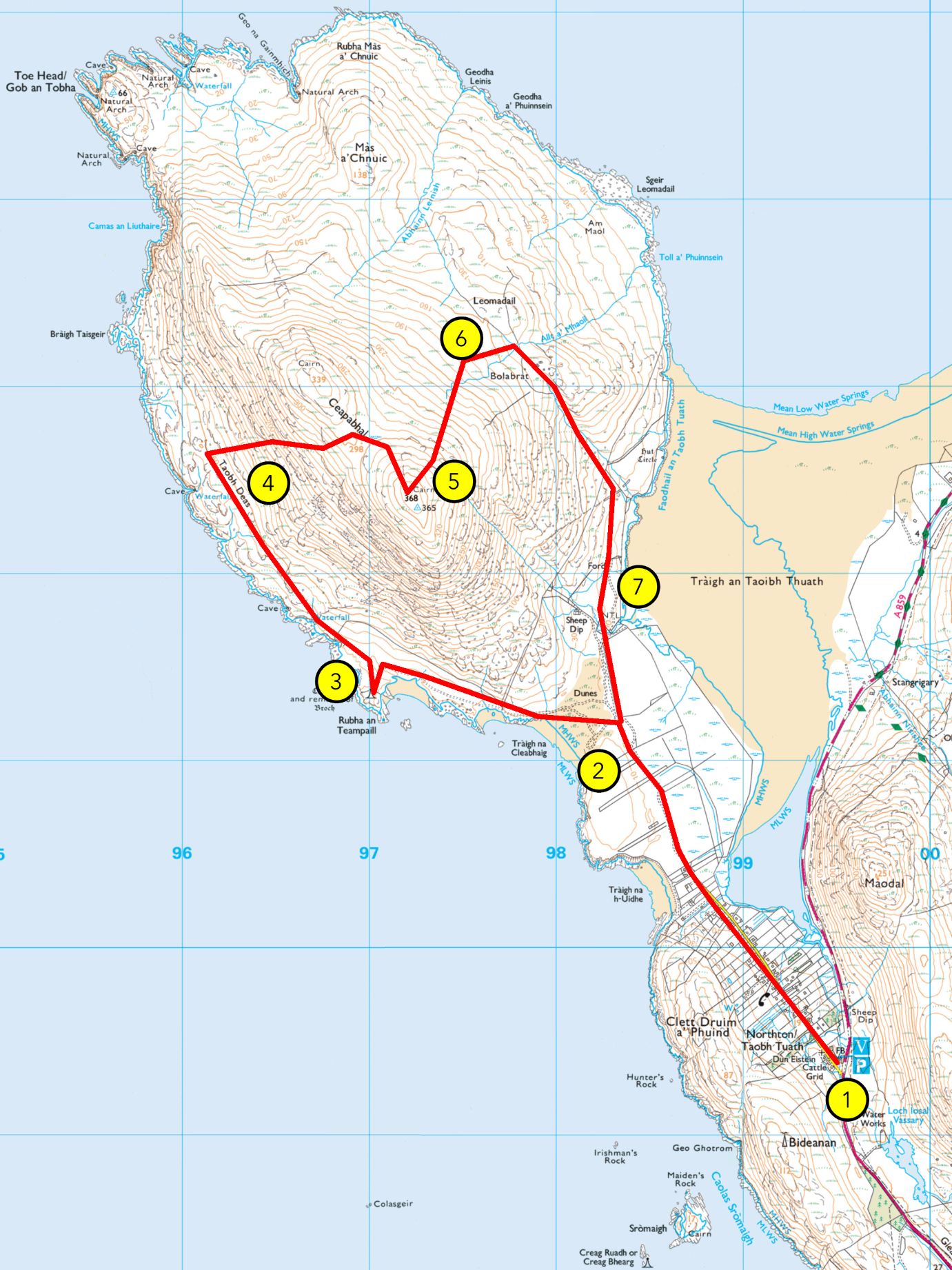
3. An Teampall
You should now stand on Rubha an Teampaill. The small chapel you see in front of you is known as Teampall na h-Uidhe, the Temple of the Isthmus. This site is much older, however. If you look around you, you’ll notice that the building stands in an enclosure made up of a low stone wall, now mostly overgrown. This used to be a broch, a type of fort that is commonly found in the area. This broch was part of a series of defensive structures located all around Harris, with a particular concentration in West Harris. Other such buildings are found in Borve, Taransay, and at Àird Grothadanais north of Luskentyre, to only name a few. Brochs are also known as dùn in Gaelic (think of Dundee, Dunoon, or Dumbarton).
The area around Ceapabhal is among the oldest known settlements of the Western Isles, with some sites dating to 3000 BC at least. The church building you can see today was built in 1528 upon an older religious site. A Christian settlement was created here by missionaries in the area before the first Viking raids of the 9th century, and the remnants of a cell used by monks for meditative isolation, were found on Eilean Hopraidh, north of Ceapabhal. The nearby island of Pabaigh, meaning “Island of the Christian Priests” in Old Norse, is another witness of that history.
If you wish to stop your walk here, you can make your way back whence you came. Otherwise, continue north and cross the drystone wall where the fence is broken, near the shore.
4. Moorland and Feannagan.
Moorland and peatlands, known in Gaelic as mòinteach, make up most of the Harris landscape. The acidic soil means that not every species can thrive here, and heather dominates the landscape, often limiting other plants. However, this landscape is richer than it appears and in the summer months you will see many plants and flowers grow in the area, including tormentil, milkwort, lousewort, marsh orchids, and much more. Boggier bits will also reveal our local carnivorous plants, the butterwort and the sundew. Moorland birds also find their fair share of insects to eat, and you should see the clacharan, or stonechat, and gocaman cuthaige, or meadow pipits, among others.
Ahead of you, the moorland landscape bears the clear traces of human activities. Those are called feannagan, or lazybeds, and consist of a series of ridge and furrow. These were common throughout Europe but are now mostly used by the people of Western Scotland and Ireland. This method allows to build more ground depth where it is irregular. In Harris, seaweed was added to the dirt to provide fertiliser. While now mostly used for potato crops, it was also used for barley, oats, and many other vegetables until a few decades ago.
Keep on ahead until you reach some ruins atop a greener knoll.
5. An Taobh Deas
You are now at the heart of An Taobh Deas. This was not a significant settlement by any means, but we have proof enough that people inhabited this place. The smaller, round buildings are shielings, which were mostly summer dwellings for people bringing their animals to graze away from the winter pasture, in order to allow them to regenerate. Other buildings burried in the heather, as well as the feannagan we have already seen, are testifying of more permanent land use. This place is known as An Taobh Deas, “the south side” in Gaelic, in relation to An Taobh Tuath, “the north side”, which used to be located north of Ceapabhal before moving to where Northton now stands.
From here, make your way up the mountain. Be careful to avoid wet slabs, and take your time.
6. Climbing Ceapabhal
From an Taobh Deas, make your way north-eastwards up the hill, aiming for the gap between the summit of Ceapabhal and the lower summit to the northwest. Ceapabhal is a steep climb from almost any direction, so take your time and be careful.
7. Mullach Cheapabhail
You have reached Mullach Cheapabhail, the summit of Ceapabhal. If you go to the top of the northernmost of the two summits, you will have a view of the landscape around you in its entirety. Around you, you will see the many islands of the Harris archipelago, including Tarasaigh, Copaigh, Siolaigh, Pabaigh, and farther south, Beàrnaraigh, the southernmost island of Harris. Farther lie the Uibhists. Far off to the west, on a clear day, you may see an enormous island, high on the horizon: This is Saint Kilda, known in Gaelic as Hiort. To the North of it, the low-lying Flannan Islands, Na h-Eileanan Flannach, are also visible.
The name of Harris comes from Old Norse Hærri, meaning “the Higher Places”, a plural still found in the Gaelic name Na Hearadh, and reflected in the contemporary English Harris. This plural quality refers to the fact that Harris is an archipelago made up of many islands, even though is is now common in English to refer to it as an island. Apart from the Harris mainland, only three islands are now permanently settled: Beàrnaraigh, Scalpaigh, and Sgeotasaigh. The others, such as Saint Kilda, Tarasaigh, Pabaigh, or Scarp, were cleared, evacuated, or slowly abandoned during the 19th and 20th century.
You may have seen the top predator of Harris flying around: the sea eagle. A family has claimed the sea around Ceapabhal as its hunting ground. The Sea Eagle, or iolaire-mhara in Gaelic, can reach 2.4m wingspan. It used to be indigenous to Scotland but was hunted to extinction in the early 20th century. The birds that fly around today were reintroduced in the 1970s and 1980s, and the species is now thriving. Inland, you are also likely to see Golden Eagles, or iolaire-bhuidhe, which have not suffered of persecution in Harris though they have elsewhere.
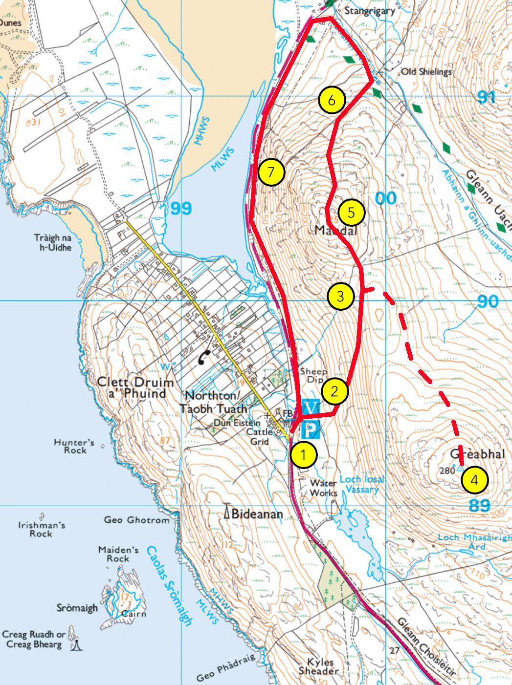
From here, make your way down to the north. You can join Abhainn Lèinis first, or aim for the green patch of grass around Leòmadail and Bolabrat. You can listen to the next recording now or as you go downhill.
8. Leòmadail and Bolabrat
The West Coast of Harris, which lies before you, is home to large stretches of machair, which explains why West Harris has some of the oldest settlements in the area. Many Scandinavian settlers built their farms here, easily recognised by the placename endings -bost in Horgabost, Seileabost, or Niseabost and -sta in Sgarasta.
The broch you saw at Rubha an Teampall was part of a series of defensive structures located all around Harris, with a particular concentration in West Harris where most of the population lived. Brochs are found in Borve, Taransay, and at Mol an Taighe north of Luskentyre, to only name a few. Brochs are also known as dùn in Gaelic (think of Dundee, Dunoon, or Dumbarton).
While seen nowadays as remote, the Outer Hebrides used to be a central point in earlier centuries, being part of Rìoghachd nan Eilean, the Kingdom of the Isles, which spanned from the Isle of Man to Lewis. This kingdom was at the heart of the great maritime routes from Norway to Ireland and beyond, and the place was once bursting with activity.
Make your way to one of the green patches of grass at the top of the low-lying hills around, either Leòmadail or Bolabrat.
This higher ground on which you stand is home to several ruins, some along Abhainn Lèinis to the west, others at Leòmadail and Bolabrat. The ruins you’ll see here are of small, round buildings in clusters. They are known as àirigh in Gaelic, or shieling in Scots and English. From at least the early Middle Ages all the way to the early 20th century, many communities in the Highlands and Islands used to practice what is known as transhumance. In the summer months, villagers would take their cattle and sheep away from the winter pastures located around their homes, to the summer pastures in the glens and hills. It allowed for habitats to regenerate and for a more balanced exploitation of the environment. The distance between the villages and the summer pastures made hill shelters necessary, and that is why people built these huts, where they would sometimes stay for the whole summer. People would watch over the animals while making cheese, butter, and other activities. It was often a task for younger members of the community, and the shieling was an opportunity for them to get some freedom from older members of the family. Shielings often appear in Gaelic and Scandinavian folktales as liminal places where strange things happen, from murders to supernatural encounters.
Once you are ready, make your way southwards, past Bolabrat and into the gully taking you back to the sand.
9. An Seann Taobh Tuath
You are now in the area that used to be known as an Taobh Tuath, or North Town. A small township was here at one time, over two hundred years ago, and a farm was later situated here, farther down by the shore.
This is the heart of the Northton Site of Special Scientific Interest. You should have reached the fence by now. As you make your way back to Northton, do pay attention to this meeting point between peatland and machair, and you’ll see that different species grow in both. We hope you enjoyed your walk and learnt a thing or two about our home.